Companies sourcing cocoa and other forest risk commodities in Ghana are now able to support their reporting and compliance...
...Companies sourcing cocoa and other forest risk commodities in Ghana are now able to support their reporting and compliance to the Cocoa & Forests Initiative (CFI) commitments using the Ghana Forest Compliance Service.
The Ghana Forest Compliance Service was adopted as the official land use maps provider for the CFI in Ghana at the Ghana Oversight Committee Meeting on 16 June 2022. The Ghana Forestry Commission, Kwame Nkrumah University of Science and Technology and Ecometrica, have come together to offer this service following a strong institutional partnership which was forged during the Forests 2020 programme.
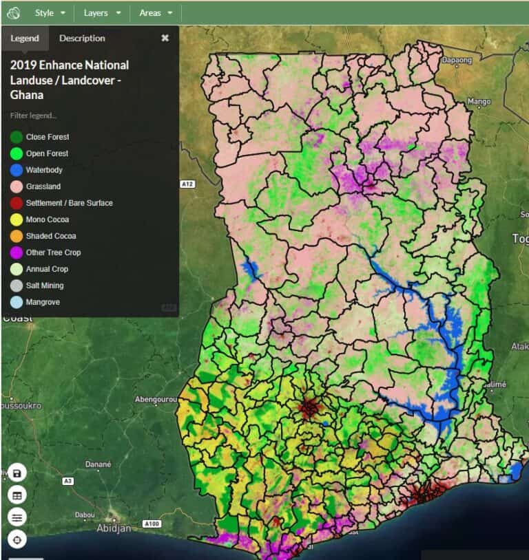
Figure 1 - The scientific breakthrough Ghana Land Use Map for 2019, which segregated cocoa monocrop, from cocoa agroforestry and natural forests for the first time.
The adoption is a landmark achievement by the Ghanaian Government and fulfills a core commitment to the CFI Initiative, providing signatories with access to historical and current land-use maps as well as forest reserves and protected area boundaries for companies sourcing in Ghana.
Within the Ghana Forest Compliance Service, companies can access a free, publicly available application to view land-use results at the landscape level from 1990-2021. A value added service is available to provide detailed reports against the key performance indicators of the CFI Action Plans for companies with large numbers of individual and collective farms within their supply chains. The value added service allows companies to obtain these reports for their specified areas on a confidential basis.
Yakubu Mohammed, Head of the Mapping Unit of the Ghana Forestry Commission said "The Forestry Commission of Ghana and our partner agencies are now in a much stronger position to determine progress towards the Cocoa & Forests Initiative objectives and other international commitments and initiatives.”
Ethan Budiansky, Director of Environment at the World Cocoa Foundation said, “The World Cocoa Foundation has been working with the cocoa and chocolate companies and the Ghanaian government to build stronger alignment and collaboration on the Cocoa & Forests Initiative and we are delighted to see the progress made on land-use mapping and the innovative service models made available to CFI companies and other partners working in the country.”
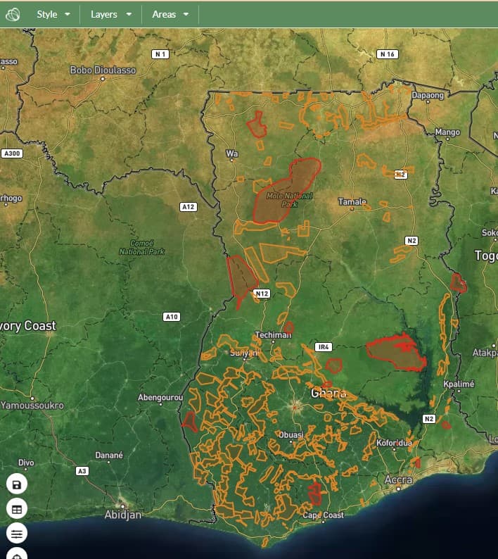
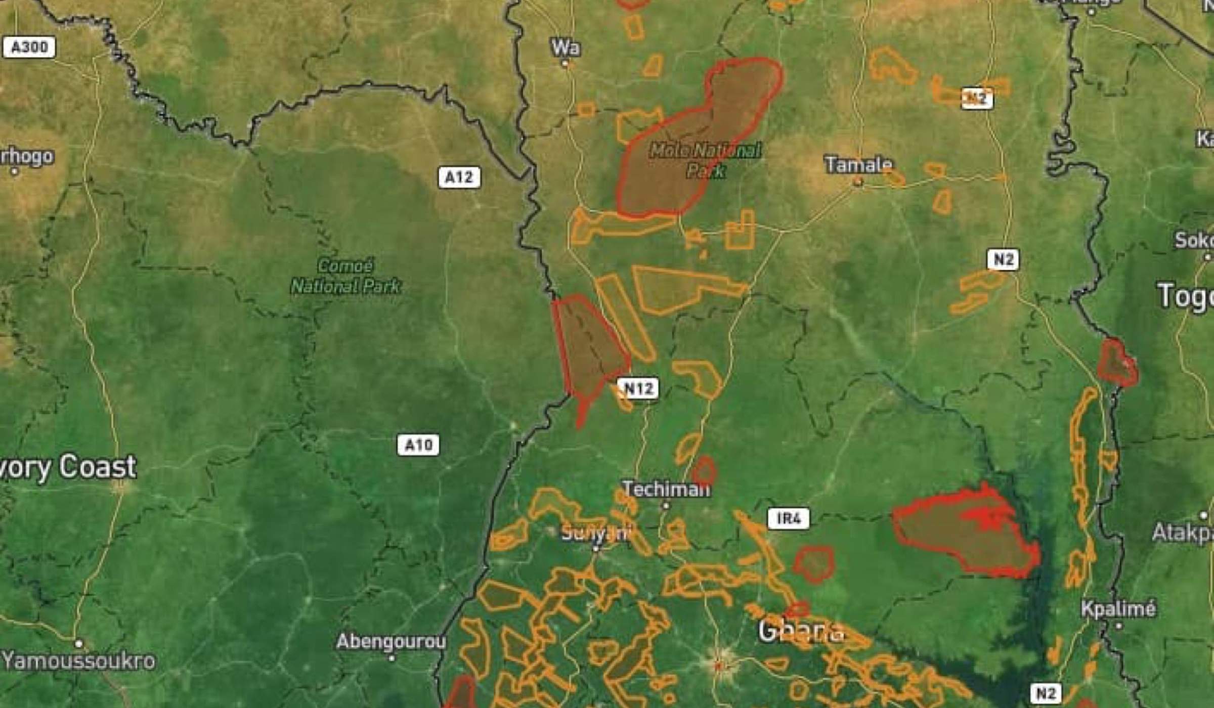
Figure 2 - Forest reserve and national park boundaries are available for CFI companies to monitor their supply chains, supplied by the Ghana Forestry Commission.
How the Ghana Forest Compliance CFI services developed
Ghana is the second largest global exporter of cocoa (after Côte d’Ivoire). One of the major challenges the Ghana Forestry Commission faced was monitoring the commodities versus the forest landscape in Ghana. Cocoa is grown both under tree shade (agroforest cocoa) as well as grown under sun (monocropped cocoa). Therefore satellite data alone is not enough to accurately monitor all the cocoa farms. As part of Forests 2020, a project by a consortium of UK experts and international partners led by Ecometrica, a land use map was developed.
The Ghanaian Forestry Commission worked closely with the Kwame Nkrumah, University of Science and Technology and the University of Leicester, to develop the land-use map production, validation and update procedures, enabling forests and cocoa farms to be monitored nationally over time. This series of land use maps enables the Ghana Forestry Commission and other CFI signatories to ensure cocoa is not sourced from land subject to deforestation.
The map was produced by the Ghana Forestry Commission using local expertise - teams on the ground essentially mapping and recording every cocoa farm and the surrounding vegetation - along with satellite imagery from Sentinel-1 satellite, in combination with optical data collected from Sentinel-2 satellite, as well as machine learning.
The resulting land-use map is one of the most accurate (approx 90%) maps of cocoa growing in the world and crucially is able to differentiate between monocropped and agroforestry cocoa, and was featured at COP26 in Glasgow.
Founded in 2008, Ecometrica is a provider of SaaS solutions that leverage data to empower companies to understand, report and act upon their climate change and sustainability impacts and partnered with the Ghana Forestry Commission to provide a digital infrastructure for the Ghana Forest Compliance Service.
How can I access the Ghana Forest Compliance CFI service?
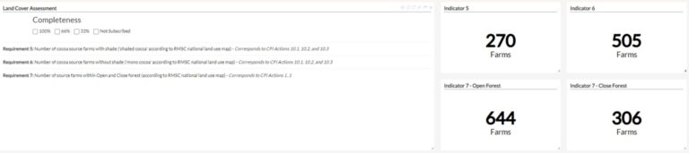
Figure 3 - An example of the Ghana Forest Compliance CFI report, with a land-cover assessment showing the number of source farms with shade, the number of source farms monocropped and the number of farms with open and closed forests - according to the RMSC land-use map.
To access the free and value added services CFI maps provided by the Ghanaian Government, visit https://www.ghana.forestcompliance.com
If you are a branded company and don’t know where your suppliers are, you can request a Ghana Forest Compliance Service CFI report as part of your purchase from a cocoa trader.
The Ghana Forest Compliance Service gives highly accurate and authoritative data across many different supply chains in Ghana. If you source another type of forest risk commodity from Ghana, get in touch here.